Bike Routes

Park & Rail Trails Book 2021 Update

A few improvements have been made to this book, but this is not a new edition, more like version 1.5. The original content is the same with minor corrections and typos fixed. What has improved are the maps and parking location listings.

User feedback had shown that some riders like a little more direction in their quest to starting a good day of cycling. My original maps gave a general sense of the scope of the ride, but lacked detail and did not tie in well with the parking suggestions mentioned.

Over the winter we all had to endure Covid isolation, which gave me some extra time at my desk. Last year, I sorted out a better way to stylize and render my maps when I published my other book, Best Mountain Bike Trails in Ontario. So with that insight, I finally took on the daunting task of updating the maps in this book.

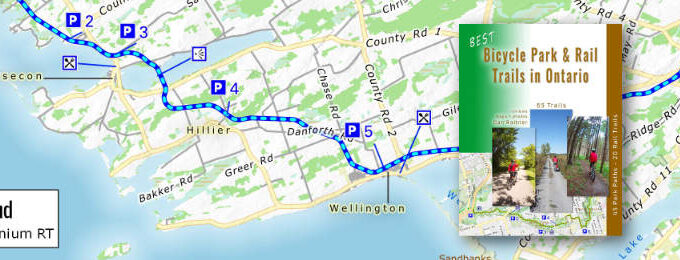
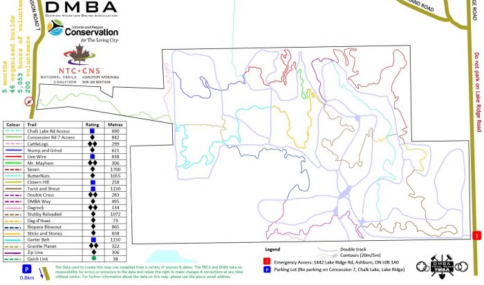
Combining GBs of map data, run through a very slow mapping program x 66 maps… well, it took months to do. Using mapping services and aerial photography I plotted viable parking locations where I could find them. These were listed for each trail review with numbers referencing parking icons on the map.

What’s New

  • Trail maps now have legible road names were space permits.
  • Maps have contoured hill shading & North compass marker.
  • Parking icons on the maps have numbers corresponding to a list of suggested parking locations.
  • A new Ontario map at the back of the book now displays of all the trail locations.
  • The eBook a has bookmarks and updated links to other websites.
Sample map

sample map

I have always intended that this book be a starting point for ideas to find new rides. Now you have more clues on how to get there and where to park. Still, you should do further research that my book cannot cover interactively, online zooming into maps and checking current trail updates, directions, weather, etc.  Some of this can be done by using this site, and/or other website resources or your favourite phone apps to plan your outings.

Here is how to interpret my parking listings. I tended to favour public lots: most have free parking and can hold 10 or more vehicles. Many are in city parks that do not have exact addresses. You will need to drive in and find them. Surprisingly, some locations have little to offer, and street parking will be your only choice. 

By doing a search of my parking addresses on Google Maps, you will get directions right to the parking lots.

For Rail Trails, almost any road crossing can manage a few cars on the shoulders. As always, be cautious in where you park to be safely away from traffic as you get ready.

These are just suggestions for parking. I leave it to your good judgement where you wish to leave your car. You could even try shopping malls—at your own peril. Always secure your vehicle and hide any valuables. After decades, I have yet to get a ticket or break-in anywhere in Ontario, but it can happen. 

I have also listed for long linear trails the start and endpoints. These have a target marker symbol by the addresses. But note not all of these locations have parking lots.

For those who have bought an older version of this book (pre-April 2021), there is a file you can download and print out as a book insert to aid in finding parking, along with the newest version of the eBook. Instructions on where and how to do that, at the back of your paperback.

Thanks to the age of digital publishing these updates can be made possible, truly amazing times. I think all my efforts should make everyone happy, have a good one, wherever your bike takes you. – Dan Roitner

May 26, 20212 Comments
Bicycle Trail & Tour Guides

After publishing two editions of my own bicycle trail guide, I got to know other guide books out there. Some are useless, while others are very inspiring to browse through and consider riding.

Whether you actually cycle any of them is secondary. Just exploring the possibilities, dreaming and scheming a way to do them is a buzz.

Here are a few guides I have checked out that will get you perhaps planning your own grand tour…far away.

Cicerone

In the U.K., Cicerone has been for a long time a big name for hiking and cycling guides. I had a few books sent to me and the quality is excellent.

You can tell the authors have ridden the routes many times. The books have plenty of detail and directions. At the beginning of the book is a primer to get familiar with the way the author rates trails.

There’s also some insight into what you need to prepare for the rides and conditions to expect. Colour maps and photos round out the guide.

Here is a sample of the two types of the many riding guides offered – MTB trails or longer cycling tours.

If you favour mountain biking, pick your flavour. The Lake District is a hilly and beautiful place in England. The rocky highlands in Northern Scotland push your limits and give you awesome views when you finally make it to the top.

Both guides give you a taste of what to expect with difficulty ratings and elevation graphs. MTB riding in Europe is different than Ontario. Expect more open established paths (centuries-old), with some side roads, farm fields and a recommended pub at the end!

Bike touring can be all road riding but I found these ones use paved path off the road too. Following along the famous Rhine, Danube or Loire Rivers gives flat terrain with scenic historic sights.

After looking at the guides, I am thinking of now doing sections of the Rhine River, one summer soon. The Loire Valley in France, I have done and it was a marvellous time. Then perhaps trying a few MTB trails in the Lake District is next.


Buy the book on Amazon – MTB Lake District, Northern Scotland or tour Rhine, Danube or Loire Rivers.

As an Amazon Associate, I earn from qualifying purchases.

Detour – Cycling Across Canada on a Recumbent

An old riding mate, Paul Stockton from the Toronto Bicycle Network, (TBN) sent me his book to read. Though I am not much of a road rider anymore, his tales of cycling across Canada from the comfort of my couch were enlightening and entertaining to read.

A few years ago he got laid off with a “package”. Just the excuse to go for a spin — a long one.

Paul has a dry sense of humour and many years of touring behind him. (India, New Zealand, Switzerland, the North Amerian Pacific coast…)

He details his daily encounters with other riders, local friendly Canadians, the ever-changing weather and contending with 11 flat tires.

To make it even more “fun” he went basic, no electronics (left his cell phone at home) and promising never to enter a Tim Horton’s on the way.  If you ever considered the journey, here is a book to get you going.

Buy the eBook or Paperback 

August 10, 2019No comments,
Where to MTB Ride After it Rains?

– A few trails to try first after wet weather –


OK you’ve got cabin fever, the snows are melting and you’re itching to put rubber on the trail. It’s been raining for days and you need to get back in the saddle, but Stop, wait it out…or ride a trail that drains well, has gravel or is paved instead.

Now some not so “nice” type A riders who can’t help themselves, are ripping up the trail way too soon, shame on you! Even though it always seems like a long winter, give nature a chance to dry out after the snow melts and the spring showers.

Before I suggest where you could go for an early ride, here are a few good reason why you should avoid the temptation to ride on more fragile areas. First it’s about preserving what little trail we have for as long as possible. Many hours may have been spent by local MTB crews to design and build tails you enjoy. Wearing them out faster is going to piss off everyone, don’t do it, water run off is enough of a erosion issue.

Trails wear out, they get wide,
they get rutted  and then they get closed.  :^(

WHY : It’s also more hazardous with greasy trails, slippery leaves/logs, deep mud puddles which make you go down more often. Ouch! Do you want to ended your riding season early with an injury?

And then your poor bike, all that mud grinds your gears, chain and brakes down real fast. Carrying a muddy bike home in your car is a mess and hosing it off at home is also ugly.

Where to Go: Here are a few trails I’ll suggest that drain well and can welcome early rabid riders. These locations, due to the high content of sand and gravel, drain quicker with few muddy spots. Many of these locations are in the sandy Oak Ridge Moraine zone.

Every place you ride should be judged as to how well it can take the erosion from your tires. Sure it’s a hoot to crank it through the pines leaving a wake of wide berms and skid marks, but that’s not cool.

Keeping your speed in check and having the skill to do a vertical and not skid out on the descent is the real challenge a seasoned mountain bike rider aims for.

Mud and erosion are part of the sport and fun, but the end game is to have the least impact on the trail, so you and others can enjoy them for years to come. Even in the middle of the summer there may be mucky puddles that never dry out. Sometime the choice is to go around them then further rut out an ever growing mud hole.

It’s about sharing and respect for the trail and other riders.


And Now the Good News:
After it Rains, the Snow is Melting, Ride Here First!

Joyride 150 – indoors
Durham Forest – northside sandy 
Ganaraska – sandy
Northhumberland – sandy

Puslinch – northside gravel
Eldred King – lots of sand
Torrance Barrens – all rock
Dufferin Forest– drains well
Long Sault – sandy
Carrick Tract – lots of aggregate mixed in

And you could always consider a Rail Trail which is gravel based or a Park path and then there’s a road ride if you must. No it’s not MTB riding but you are on a bike and it could be good spring training.


AVOID these trails for 2+ days after it rains : 

Don Valley- greasy
Kelso – will be closed
Ravenshoe – greasy, poor drainage
Couslon’s Hill – slippery slope
Albion Hills – muddy, greasy 
Waterdown – slippery mud

Please respect the trail…and have FUN!


April 8, 20172 Comments, Popular
How the Dagmar MTB Trails Returned

A new MTB  trail just opened east of Toronto by Durham Forest called Dagmar North Trails. As I was riding it for the review on this site, I wondered what it took to reopen after being closed for 11 odd years.

So I interviewed John Fisher of the Durham Mountain Biking Assoc. (DMBA) who is on the executive. (and just happens to live near the trailhead – sweet!) He gave me the back story on this great achievement for the mountain bike community. Any major trails building endeavour needs –  approval, money and manpower plus takes plenty of time (years) to reach.

He explained that years ago when the Dagmar Ski Resort decided not to give access to their parking lot the Toronto and Regional Conservation Authority (TRCA), who own the land had no other choice but to close the trails and try to find a solution. As it sat idle for years,

the TRCA and DMBA were laying out a management plan to cut better, more suitable trails. Actually during that wait for studies and approvals, the club worked on a few new trails in Durham Forest since this area is approved.

What got the project really moving was funding from the National Trails Coalition (NTC) with $20k and 2 connector trails to the property. The TRCA obtained a right of way from Chalk Lake Rd. across a farmers field (connection to Durham Forest) and opened a trail from Concession Rd. 7. (connection to Glen Major)

DMBA fronted $20k of their own funds with the intent of recouping it back through membership and donations. We are at $13k says John and anyone enjoying the trails should consider donating or joining. IMBA helped with training trail builders the right way to lay a single track.

Then 200 volunteers, most from DMBA’s 700+ members, came out to put in over 5500 hours of work clearing, grading the land and adding logs, stumps, rock gardens, berms and retaining walls. A few tasks like cutting most of the trail benches were done with hired machinery. Maps and sign posts were added and are to be improved soon I am told.

Future plans are to build two more trails there, one will connect to the south parking lot at 3 Rocks. The clubs has also been in conversation with various government agencies to consider connecting  trails to the north with Uxbridge, and the Rogue Valley National park to the west . John mentioned that the Rouge has finally been approved for MTB trails to be added and that’s an exciting prospect. DMBA has also had a voice in keeping MTB trails in Jefferson Forest.

It was John and Tom Hawks dream to reopen the Dagmar trails and many of us are glad they carried through. As you can see it takes plenty of effort to build legal trails. And the DMBA continues to do great advocacy work to give the sport of mountain biking a good name and open doors for future MTB trails….and FUN !


Dagmar bike-trail-map

Dagmar MTB trail map

October 11, 20152 Comments,
New Bike Rides Up North

As this cool summer winds down, I would hope you have been  wearing out your bike exploring a few new trails on our map. I have been out scouting some new rides up north where some of you may wander for a vacation or pass through.

I found two great rocky MTB rides in Sudbury – Naughton & Laurentian, (there I am on my bike in the photo) another in Algonquin – Minnesing and a rail trail as well. If you still have time this fall check these locations for they are great rides with no bugs by now and beautiful fall colours soon.

On another front, I was out London way and scouted out a few trails. Fanshawe is on the map with others to follow.

Ottawa and Niagara were recently toured so look for a few of the choice rides from those regions to be posted on the map.

Also posted on the map is a new BMX ride park that Toronto riders have been forever waiting for – Sunnyside.

It’s been a good summer to be out on a bike. Few weekends were rained out and the high humid heat was almost nonexistent. There are still a few good months of cool riding to be had. If you dress for it, one can ride right into the winter. With fat bikes as the latest trend your ride can be year round.

Let me know what you think of the trails and add a review or comment.

Ride on….Dan R.


August 29, 2014No comments, EPIC
Awesome New MTB Trail and…

There is a new destination out there that few of you may know. I myself gave it a spin just recently after hearing rumors of something being built out in Peterborough.

The Harold Town trails were officially open this month and they rock. This old ski hill was carefully transformed by dedicated local MTB riders into an awesome ride. The kinda ride we all wish for. Non stop FUN! Really, you never get bored and the challenges keep on coming.

Designed by IMBA standards most of the track is MTB cut, with only a few hiker trails to connect. Read my review and try it once, you’ll love it.

Another NEW spot is in Toronto. The Sunnyside BMX Bike Park is now open. More on that next time.

There have been other trails posted recently on the map for more mellow city riders. Now we are at 52 rides posted with double that in the que. And this site is officially launched!  Unlike other sites we do not publish random inaccurate submissions. All the rides here researched and most ridden to insure better accuracy for you to pick your next ride.

Here are recent additions to the map:

North Simcoe –  easy Rail trail ride in mid Ontario countryside

Heber Downs – small Park ride east of Toronto

Taylor Creek – scenic Park ride in Toronto

Dundas Valley – Large forested Park ride beside Hamilton

Hamilton to Bradford – one of the best Rail trails

Greenway – central Park/Rail trail in Peterborough

Have a great summer on the trails. I’ll be out there doing ride recon on more distant destinations in Ontario. Enjoy the great outdoors.

Dan Roitner


July 18, 2014No comments,
Send this to a friend
Hey, this may be interesting for you: Park & Rail Trails Book 2021 Update!

This is the link: https://ontariobiketrails.com/park-rail-trails-book-2021-update/

Lets get together and do a ride soon.