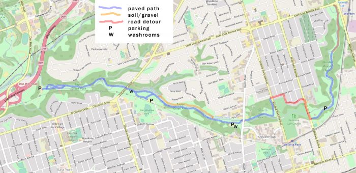
Length – 6 km (one way)
80% park path
10% gravel path
10% roads, crossings, detours
Elevation – Flat, with a few dips at the water and a gradual incline up from the creek.
Terrain – Mostly asphalt and smooth soil, with some gravel and sandy patches; alternate water crossing.
Skill – Easy to Intermediate
Traffic – Well-used by bicyclists, hikers, and dog-walkers.
Maps – A map is found at the trailhead, as well as signs along the trail.
Facilities – Four parking lots, as well as washrooms and benches along the trail.
Highlights – Bridges, ponds, and lovely colours in the fall.
Trail Fee – Free
Phone – Toronto 311
Website – City of Toronto
Similar Trails – Highland Creek, Humber Valley, Morrison Valley
Local Clubs – Toronto Bicycling Network (TBN)
Access – Find parking lots at: Pharmacy Rd., Dawes Rd., the bottom of Haldon Ave., and by the DVP when entering from Don Mills Rd. (but check a map, as the entrance has no sign!). From the other end, the subway stops at Warden Woods if you wish to use the TTC.