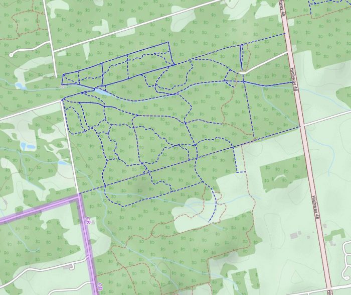
Eldred King – MTB / Park Trail

16232 Hwy 48, Ballantrae
Posted on February 16, 2019 / 8778
Eldred King – MTB / Park Trail
Listing Types : MTB Trail / Park Trail
Total Trail Km : 20
MTB Track % : 30
Double track % : 40
Hiking trail % : 30
Rate Skill Levels : Easy, Intermediate
Terrain : sandy spots, smooth soil, logs jumps, crushed gravel, can be muddy, bridges, flat sections, drains well, gentle hills, steep hills, open field, tree roots
Faclities : parking
Trail Fee : Free

Length – ~20 km

30% MTB single track
30% hiking trail
40% double track access roads

Elevation –  small – med hills, mostly flat access roads, the single track can get hilly

Terrain – gravel roads, smooth soil, muddy spots, some very sandy stretches, horse patties!

Skill – easy to moderate ride for MTB or Park style rider

Maps – basic at the trailhead, no other signage, MTB track can be hard to find

Facilities – large parking lot, outhouse maybe?

Highlights – pond and dam, fun to explore, sand for Fatbikes

Trail Fee – free

Phone – 905-895-1281

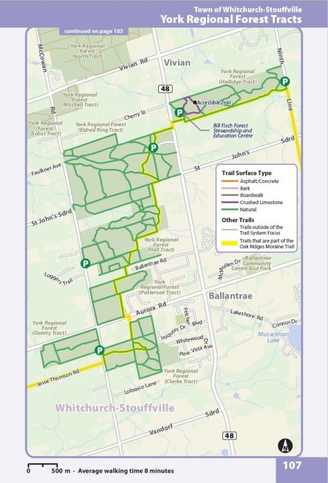
Website – York Region

Similar Trails – GanaraskaNorthumberland, Palgrave

Access – Aurora Rd., north on hwy. 48 Markham Rd. to # 16232, go down the gravel road on the westside for parking in Eldred King Forest Tract sign.

Trail access is in any direction west from parking. Best/most trails head SW.

mtb trail guide
Vol 2 Bike Trail Book Ad

Eldred King Forest Tract, north of Markham, is a little known, medium-sized ride area for MTB riders to try at least once. Great spot for beginners.

Also, Intermediate Park style cyclists can find plenty of access roads to ride if you have wide tires to ride the dirt and sand.

You will find only a map at the trailhead, so use your phone app or print one out. The roads and tracks have no signposts and run every which way. So this is a place to explore and find your own adventure.

Getting to the single track among the access roads is the tricky part. As there are no signs and few entry points. But once you get in, and ride around you will be delighted at the amount of trail which flows well.

Most of the MTB runs are is on the south half of the map with a few hilly spots that will keep it fun and challenging enough. Every time I go, I find even more twisty MTB trail.

Some of the side trails are carved out by local horse riders. You will know it, as they are more straight and lumpy from the hove marks left behind.

Unlike other ride spots I know, you may likely meet a horse and their poop on the trail, which in itself is a technical trail obstacle. (lol)

Note: When you see a horse, stop ahead and ask the rider how the horse may react. Some horses have never seen an alien mountain biker, they may get spooked, and throw the rider/kick you. 

Also, expect to see dog walkers near the parking lot and pond.

This mixed pine and hardwood forest is logged at times in the winter. A few areas have large swaths of sand that are next to impossible to ride. (unless it has just rained)

Large swaths of sand found here, is probably why it is not an all-around popular spot. Though perfect for unstoppable Fatbikes!

I have not checked out all corners of this forest tract. Southwest of the parking lot, it goes for a good stretch in many directions. At one point I came across an archery range, not sure where.

I have included another map to show even more trail you could explore. Some of these routes are straight dirt roads others sand traps or dead ends.

Yet you may find something special on your adventure if the trail calls you to try them.

Read my New review for Eldred and 54 other locations in my MTB guide book.

Eldrid King bike trail map

Eldrid King bike trail map

Eldrid King and other trails beyond

Reviews
3.4
Total Score 1 REVIEW
Fun Factor: Scenic: Trail Design: Technical: Workout:
Leave a review
Fun Factor: Scenic: Trail Design: Technical: Workout: