Harbourfront – Park Trail

Queens Quay, Toronto
Posted on May 8, 2018 / 9770
Harbourfront – Park Trail
Listing Types : Park Trail
Note : EPIC Ride
Total Trail Km : 9
Park Path % : 95
Road % : 5
Rate Skill Levels : Easy
Terrain : paved, flat sections
Faclities : parking, food close by, toilet, outhouse, drinking water, change rooms, lodging, good signage, trails maintained, bike rentals, pro shop
Trail Fee : Free

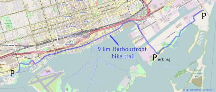
Length –  9 km (one way)

95% park path
5% road, detours

Elevation – flat, follows along Lake Ontario

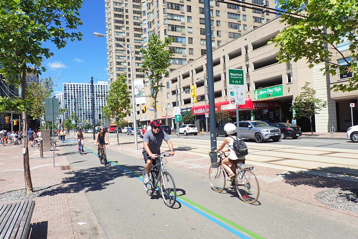
Terrain –  paved asphalt with line, all designated bicycle paths, a few road crossings

Skill – easy, but pay attention to bike stop signs and meandering tourists

Maps – a few maps on route, well marked path

Facilities – restaurants, pubs, boat tours, bike rentals, shopping,  TTC, washrooms (Cherry Beach, Coronation Park)

Highlights – waterfront, boardwalk, Cherry and Sugar Beach, Wavedecks, Toronto Music Gardens, Harbourfront Centre, Powerplant Art Gallery

Trail Fee – free

Phone – 416 973 4000 or 311

Website – Harbourfront Centre,  Waterfront Trail

Similar Trails – Beaches Boardwalk, Toronto Island, Ajax Waterfront

This path (The Martin Goodman Trail) continues west along the shoreline past the Humber R. and on the eastside to the Beaches. It also connects up with the Don Valley trail north. And if that is not enough to keep you busy the ferry to the Toronto Islands are at the bottom of Bay St. for more touring. (though currently closed till August, due to high lake levels)

Local Clubs – Toronto Bicycle Network, Toronto Bicycle Club

Access –  One can park on either end as a start point, Ontario Place parking lot (cost $), on the eastside for free along Leslie St. and in the lot of the Thompson Park. And Cherry Beach has a lot too. Driving through the harbourfront is not car friendly.


This 9 km section of the Martin Goodman bike path along Lake Ontario’s shoreline is likely the most popular ride in town, and for good reason. 

Going through the centre of Toronto’s continually evolving waterfront, offers many sights and things to do for the locals and tourists.  

Plan to stop a lot, as there are numerous places walk along the boardwalk, have lunch, hear music, see artisans and buy their crafts. There are also a few galleries and gardens to meander through. 

Having ridden this path for many years, I have waited till now to finally say it’s ready to ride. After much redesign, upgraded and construction, it is finished!

The result is a joy to ride and a lot safer than before to navigate through the centre of Toronto’s touristy Harbourfront area on a designated bike lane of our own which does not share the road with cars.

Most of the route is not a true “park” setting with trees and lawns as it cuts across downtown, but it sure is fun to do.

Starting from either Ontario Place on the westside or on the eastside at the entrance of Tommy Thompson Park this makes for an easy, bike ride for the whole family.

This paved path is wide, flat with only a few road crossing (at the lights) to manage. And welcomed refreshing cool lake breeze adds to the outing on a hot summer day.

Bike riding from the east, the path from the Unwin Ave. bridge going west to Cherry Beach has a nice stretch of…


Read more of this review in my trail guidebook with better maps, and suggested parking available as an eBook or paperback.

Vol 2 Bike Trail Book Ad

Open Street Maps 

Harbourfront bike trail map

Harbourfront bike trail map

Reviews
4
Total Score 1 REVIEW
Fun Factor: Scenic: Trail Design: Technical: Workout:
Leave a review
Fun Factor: Scenic: Trail Design: Technical: Workout: