Niagara River – Park Trail

Niagara on the Lake to Fort Erie
Posted on June 2, 2018 / 11663
Niagara River – Park Trail
Listing Types : Park Trail
Location : Central Ontario
Note : Popular
Total Trail Km : 53
Park Path % : 90
Road % : 10
Rate Skill Levels : Easy, Intermediate
Terrain : paved, crushed gravel, bridges, flat sections, gentle hills
Faclities : parking, food close by, toilet, outhouse, drinking water, lodging, good signage, trails maintained
Trail Fee : Free

Length –  53 km (one way)

90% park path
10% road, crossings, detours

Elevation – gradual slope from Lake Ont., large switchback at Queenston then level to Lake Erie

Terrain – wide path, paved asphalt, some crushed stone & gravel, road riding in Niagara Falls

Skill – easy

Maps –  signs and maps on trail

Facilities –  parking on street, washrooms, food, water, lodging, bike rentals

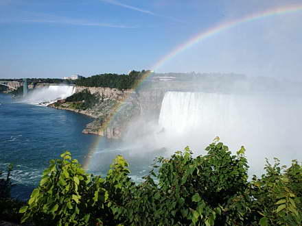
Highlights – very scenic ride!, Niagara falls, large river, lookouts, garden parks, estates, forts, historic towns

Trail Fee – free

Phone – 1 800 563-2557

Website – Niagara Cycling Tourism, Niagara Falls Tourism,  Niagara Parks

Similar Trails – Hamilton Beach, Ajax Waterfront, Welland Canal

Local Clubs – St. Catharines Cycling Club, Niagara Freewheelers

Access –  A popular trail with many parking lots to start from along the Niagara Parkway.


The Niagara River Recreation Trail is one of the best Park trails in Ontario. As this 53 km trail is paved, it is a well-used path that winds along the Niagara River. You’ll never get bored of the sights and attractions.

The mighty Niagara Falls is undoubtedly the big draw and is located in the middle of this route. Other highlights are lookouts over the river gorge and the fast-flowing water, as well as stately homes, flower gardens, quaint eateries, historical statues and forts.

Since it is 100 km return-trip, I typically ride only from one end or the other—to the Falls and back.

There is one main difference between each section. Above Niagara Falls, riding in north from Fort Erie, the river flows just a few metres below the riverbank trail.

However, if you ride south from Niagara-on-the-Lake to the Falls, the trail starts close to the river and contains an approximately 100 m switchback at Queenston. From there to the Falls the now-turbulent river is way below in the gorge.

Take a moment to visit the quaint and historic parts of Niagara-on-the-Lake and Queenston. Or, you may like the buzz of tourists and bright lights of Niagara Falls. Fort Erie is more of a working border town, with a Rail trail that carries on along Lake Erie.

This well-maintained paved path is free of cars and runs parallel to the road through picturesque parkland.

Watch for the many crossovers at…


Read more of this review in my trail guidebook, plus 64 others. Featuring better maps, parking locations and elevation graphs. Available as an eBook or paperback.

Vol 2 Bike Trail Book Ad

Niagara bike trail map

Niagara bike trail map

trail is blue line

Reviews
3.9
Total Score 4 REVIEWS
Fun Factor: Scenic: Trail Design: Technical: Workout:
Leave a review
Fun Factor: Scenic: Trail Design: Technical: Workout: