LE & N – Rail Trail

Brantford to Port Dover
Posted on September 28, 2018 / 17886
LE & N – Rail Trail
Listing Types : Rail Trail
Location : Western Ontario
Note : Cruising
Total Trail Km : 46
Double track % : 95
Road % : 5
Rate Skill Levels : Easy
Terrain : paved, crushed gravel
Faclities : parking, food close by, toilet, outhouse, drinking water, lodging, trailhead map, good signage, trails maintained
Trail Fee : Free

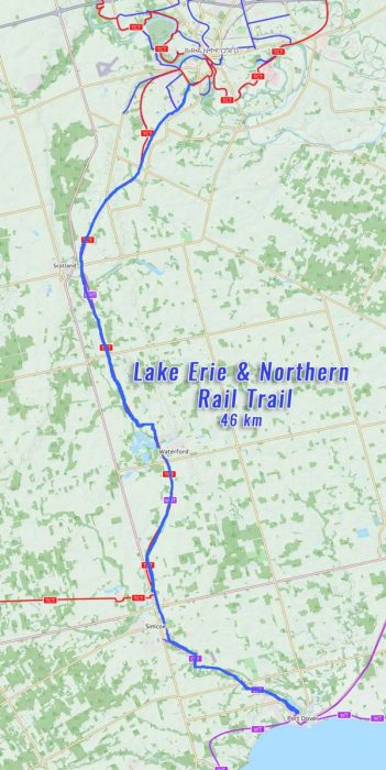
Length – 46 km (one way)

90% rail trail path
10% road crossings, detours

Elevation – flat with very gradual slope

Terrain – crushed stone, some gravel, asphalt (more than usual) road crossings

Skill – easy

Maps – map board at gate

Traffic – bicycles, hikers, dogs, X-country skiers –  No E-bikes on Lynn Valley

Facilities –  parking, outhouse, benches, picnic tables, lodging and eats in Brantford, Waterford, Simcoe and Port Dover

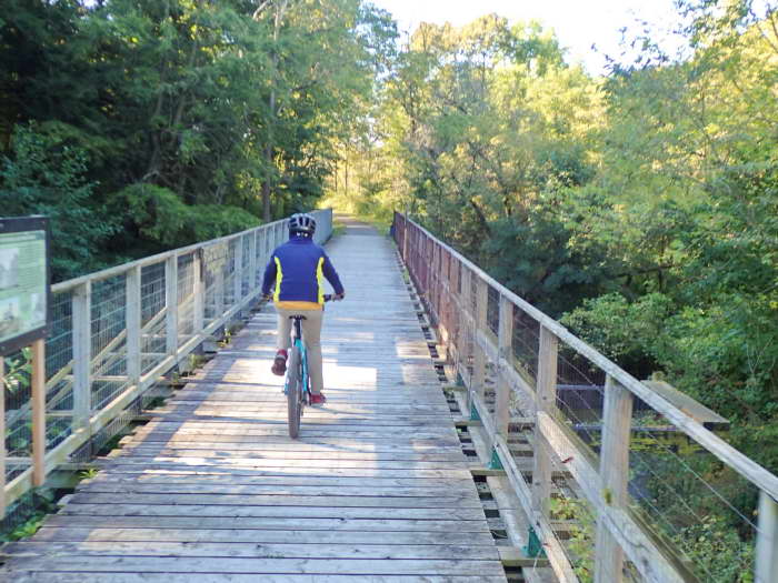
Highlights – railroad bridges (large in Waterford), shaded woodlots, old farming communities

Trail Fee – free

Phone – none

Website – Norfolk Pathways,  Norfolk Tourism,

Similar Trails – Kissing Bridge, Omemee,

Local Clubs – Turkey Point MTB Club, Bike Fit Sunflowers, Short Hills Cycling Club

Access – most side roads crossings, parking suggestions:

  • Brantford – end of Beckett Dr.
  • Waterford – west end of Nichol St.
  • Simcoe – Argyle St. (map flag)
  • Port Dover – Silver Lake Lions Park


The LE & N Rail Trail was once the Lake Erie & Northern Electric Railway before it was repurposed as a recreational trail to cycle on. At 46 km, this section runs from Brantford to Port Dover.

As a popular and well maintained rail trail, it travels south to Lake Erie across farm fields, through many woodlots and a few old towns which this train line served to transport people and goods.

Now on the site map, it’s one of the best Rail Trails so far and worth an overnight stay at any of the towns on the way. And to check out plenty of other attractions down in Southern Ontario.

Local counties have taken parts of this route and given it their own names but riding the path remains the same.

As it leaves Brantford from the Veterans Memorial Pkwy, it is called the LE & N Trail and goes for 14 km. It passes by neighbourhoods and curves gently out of town along a shady tree-lined path to more open farm fields.

Eventually it meets up with another Rail trail, the TH & B (Toronto, Hamilton & Buffalo Railway), which joins it and gives bike riders another way back.

Then for 18 km, it’s called the Waterford Heritage Trail, as it passes through Waterford where the rail trail splits (take the left path) and it goes up over a large bridge then past grain silos. Below you can see how this valley had other rail lines running under it. (which you can ride)

The name changes again briefly to the Norfolk Sunrise Trail for 4 km as it enters the town of Simcoe, where it finally becomes the Lynn Valley Trail for the last 10 km…


Read the rest of this review in my trail guidebook along with 64 others. Featuring train history with better maps, contour graphs and parking suggestions when you buy the eBook or paperback.

Vol 2 Bike Trail Book Ad

Reviews
4.1
Total Score 9 REVIEWS
Fun Factor: Scenic: Trail Design: Technical: Workout:
Leave a review
Fun Factor: Scenic: Trail Design: Technical: Workout: