Tommy Thompson – Park Trail

1 Leslie St. & Unwin Ave., Toronto
Posted on May 18, 2018 / 12674
Tommy Thompson – Park Trail
Listing Types : Park Trail
Note : Cruising
Total Trail Km : 12
Hiking trail % : 10
Park Path % : 30
Road % : 60
Rate Skill Levels : Easy
Terrain : sandy spots, smooth soil, paved, crushed gravel, bridges, flat sections, open field
Faclities : parking, food close by, toilet, outhouse, drinking water, change rooms, trailhead map, good signage, trails maintained
Trail Fee : Free

Length – 12 km , 5 km to point (one way)

30% park path
10% hiking trail
70% road (closed to vehicles)

Elevation – road is pancake flat, dips to cross water bridge, climbs to get to light beacon.

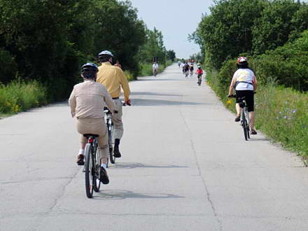
Terrain – wide closed asphalt road, side trails gravel, watch for broken brick, glass and chunks of metal as this peninsula was built with construction waste.

Skill – all levels, very easy

Maps – sign a gate, side trail signage

Facilities –  parking on street and lot, outhouses, welcome centre (area under long term construction)

Highlights –  Toronto skyline, nature photography, bird watching, hiking, swimming in lake, quite

Hours – Weekdays: 4 p.m. – 9 p.m.
Weekends & Holidays: 5:30 a.m. – 9 p.m.

Tommy Thompson Park is open all holidays except Christmas Day, Boxing Day and New Year’s Day.

Trail Fee – free

Phone – 416 661 6600

Website – TRCA , T. Thompson Park

Similar Trails – Beaches Boardwalk, Hamilton Beach, Ajax Waterfront

Local Clubs – Toronto Bicycle Network, Toronto Bike Club

Trailhead –  Gate located at the foot of 1 Leslie Street and Unwin Ave., south of Lakeshore Boulevard East. Park on street or lot inside on the westside.

New bike trail entrance from Unwin Ave to park by bridge.


Tommy Thompson Park (Leslie Street Spit) is a long, flat bicycle cruise out to Lake Ontario. It’s an oasis in the middle of a busy city to which cyclists can retreat.

The path is mainly a straight asphalt road. Thankfully, there are no longer any dump trucks running along it to make this man-made peninsula.

It is flat—with a few speed bumps, what? Take a short, 5 km to the point with the lighthouse on the hill.

Sadly, it is not a historic lighthouse, just a simple light beacon, yet the view is worth the climb. Once you reach the floating bridge, you are two-thirds there.

Being a paved road, some find this route a bit dull. Yet it does offer an escape from hectic city life and vistas.
The air is fresh and the surrounding land serene. The scenery provides numerous views of the Toronto skyline, as well as the Beaches shoreline.

Built over the last 60 years, this peninsula is made of landfill from construction sites. Hence, it is slowly transforming itself from a waste zone to a wildlife and recreational area. Birding, hiking, and photography opportunities abound.

However, care must be taken as the ground has numerous waste material hazards which may puncture your tire if you wander off the paved Park trail.

There is an alternate, triangular route you may use to return. Exploring this…


Read more of this review in my trail guidebook, plus 64 others. Featuring better maps, more parking locations and elevation graphs. Available as an eBook or paperback.

Vol 2 Bike Trail Book Ad

Open Street Maps

Tommy Thompson bike paths

Tommy Thompson bike paths

Reviews
3.6
Total Score 2 REVIEWS
Fun Factor: Scenic: Trail Design: Technical: Workout:
Leave a review
Fun Factor: Scenic: Trail Design: Technical: Workout: