Thornton – Beeton – Rail Trail

4585 15th Line, Cookstown
Posted on August 28, 2020 / 7035
Thornton – Beeton – Rail Trail
Listing Types : Rail Trail
Location : Central Ontario
Note : Popular
Total Trail Km : 19
Double track % : 95
Road % : 5
Rate Skill Levels : Easy
Terrain : crushed gravel, bridges, flat rock, drains well, open field
Faclities : parking, food close by, toilet, outhouse, drinking water, trailhead map, good signage, trails maintained
Trail Fee : Free

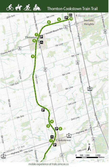
Length –  19 km (one way)

95% rail trail path
5% road crossings, detours

Elevation – Flat, actually it slopes up north 80 m

Terrain – Crushed stone, bridges, road crossing

Skill – Easy

Maps – Map boards, trail posts signage

Traffic – Bicycles, hikers, horses, snowmobiles, X-country skiers

Facilities – Parking lots, outhouse, benches on trail, amenities in Cookstown and Thorton 

Highlights – Many bridges, scenic views, towns of Thorton and Cookstown

Trail Fee – Free

Phone – 705 435 3900

Website – New Tecumseth, Simcoe County

Similar Trails –  Caledon, Sutton – Zephyr, North Simcoe

Local Clubs – Toronto Bicycling Network – TBN

Access – Parking  in

  • Cookstown on Innisfil 5th line sideroad
  • north of Cookstown on hwy 27 
  • Essa 5th sideroad
  • Thornton hwy 27 
  • Hwy 53 north

History – (I no longer include train history in my free reviews. Only to be found in my published books.)


Winding it’s way up towards Barrie, the Thornton – Cookstown Train Trail is another section of rail line repurposed for some fine leisure cycling. This 19 km segment of the line was once part of a much longer route from Hamilton to Collingwood and beyond.

My friend and I started the ride at a parking lot on the edge of Cookstown. I was uncertain how far south the path could go so we rode north to Thornton first. The trail seemed already well known and used by many hikers, joggers and cyclists, this was my first time.  

I could see why, it was well maintained, scenic and an easy route to follow. The trail base is your typical fine crushed stone all the way. There are a  few road crossing, some quite others need attention to oncoming traffic. A gravel or hybrid road bike can manage this terrain nicely, though watch for the loose grit at times.

This bike ride is about 60 km north of Toronto and can be reached quickly being just west of Hwy 400. Afterwards, there are plenty of places to find lunch on a patio and play the tourist travelling around to the local towns.

Those who like to stop on route for a coffee and a muffin will appreciate that both towns on the way have opportunities to indulge.

The landscape changes frequently from treed sections to open fields. Most of the route is not shaded, so the lack of trees gives way to expansive views of crop fields, pastureland and marshy areas.

While doing my primary research on this bike path I could see that this trail might one day go further on in both directions. From aerial photos, could it one day go right into Barrie? Maybe to the waterfront, that would be great!

I am unsure about the current status, but read there are plans to extend the trail to 26 km in time. I’m guessing the other direction towards Beeton.


Read the rest of this review and 59 others in my NEW book, Volume 2 of Best Bicycle Park & Rail Trails in Ontario.

Vol 2 Bike Trail Book Ad

Rail Trail Map

Thornton Cookstown bike trail map

Thornton Cookstown bike trail map

Reviews
3.7
Total Score 2 REVIEWS
Fun Factor: Scenic: Trail Design: Technical: Workout:
Leave a review
Fun Factor: Scenic: Trail Design: Technical: Workout: