The Pines – MTB Trail

745751 Township Road 4, Woodstock
Posted on June 8, 2020 / 10512
The Pines – MTB Trail
Listing Types : MTB Trail
Location : Western Ontario
Note : New Trail
Total Trail Km : 20
MTB Track % : 85
Double track % : 5
Hiking trail % : 10
Rate Skill Levels : Easy, Intermediate, Advanced
Terrain : sandy spots, smooth soil, structures, logs jumps, can be muddy, bridges, flat sections, drains well, gentle hills, twisty & gnarly, tree roots
Faclities : parking, toilet, outhouse, trailhead map, trails maintained
Trail Fee : Yes

Length – 20 km

85% MTB single track
10% hiking trail
5% double track access roads

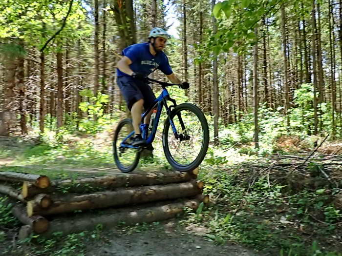
Terrain – flat by the river, short hills in the interior, flowy bermed single-track, log hops, bridges, tight turns, a few ramps

Surface – smooth soil, lots of roots, pine needles, some sand and gravel, can get muddy

Skill – easy to intermediate

Maps – at trailhead, good post signage

Facilities – large parking lot, outhouse

Highlights – well treed, maintained by club

Trail Fee – $10 non-member, yearly $35

Phone – none

Website – Woodstock Cycling Club

Similar Trails – Fanshawe, Wildwood, Christie Lake

Local Clubs –  Woodstock Cycling Club,   Facebook

Access –  Not the easiest parking lot to find. Go to 745751 Township Road 4, north east of Woodstock. Down long gravel road to parking lot. Trailhead on the west side by map.

Open year round and for night rides


The Pines near Woodstock, in the middle of central Ontario, is an oasis of fast MTB riding for all those in need of some cycling action. On the banks of the Thames River northeast of town, this woodlot has around 20* km of twisty trail jammed into it.

The pine trees planted in orderly rows somehow gave the local bike club that manages this property the right idea: they snaked trails around the trees every which way for gnarly MTB manoeuvring with little straightaways or doubletrack to bore you.

This area is pretty flat, being by the river, with a smooth, sandy trail base that drains well and little rock to be seen.

A small hill in one quadrant gives a meagre 15 m of elevation gain. It’s still enough to tear through Broken Shoulder and Cardiac Hill to Belgian Waffle’s fast and flowy loops, a favourite of mine.

Twisty has the flat, easy stuff by the river and is, as you might expect, serpentine. On the west side of the trailhead is a short, scenic loop called Dropped Nuts going into Three Bridges with…Ummm, yes, bridges, a rock garden and a large ramp to roll over a tree trunk—what fun.

Author’s Note − At this point, I had to rewrite the rest of this review for the book. At the 11th hour, someone emailed me with the news: spring logging had trashed the place, and most of the loops had been changed!  What else could do I but drive there the next day to scout it out with my son?

And it has improved dramatically, more jumps, more speed, more…


Read more of this review in my MTB guidebook with better topo maps and riding tips, plus 54 others. Available as an eBook or paperback.

mtb trail guide

The Pines MTB trail map

Reviews
4.1
Total Score 4 REVIEWS
Fun Factor: Scenic: Trail Design: Technical: Workout:
Leave a review
Fun Factor: Scenic: Trail Design: Technical: Workout: