Greenwood – MTB Trail

Church St. & Whitevale, Ajax
Posted on July 25, 2019 / 8229
Greenwood – MTB Trail
Listing Types : MTB Trail
Note : New Trail
Total Trail Km : 20
MTB Track % : 40
Hiking trail % : 40
Road % : 20
Rate Skill Levels : Easy, Intermediate
Terrain : sandy spots, smooth soil, structures, logs jumps, crushed gravel, water crossing, can be muddy, bridges, gentle hills, steep hills, open field, twisty & gnarly, tree roots, rocky patches
Faclities : parking, food close by, toilet, outhouse, trailhead map

Length – 20 + km

40% MTB single track
40% hiking trail
20% double track access roads

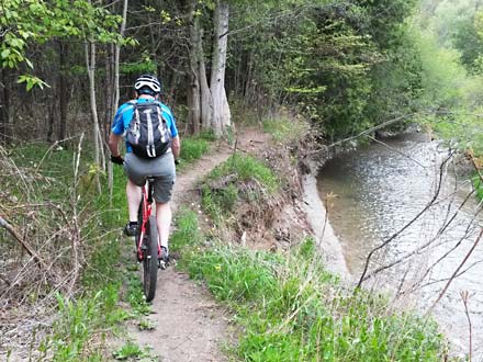
Terrain – flat on ridge, deep ravine, short hills , some steep

Surface –  smooth soil (will be slick when wet), sandy spots,  some gravel at the old pit

Skill – Trail for all levels, best for a Intermediate rider

Trail Fee – free

Facilities – 3 parking lots, outhouse? , amenities south in Ajax

Highlights – large area to explore, still underdeveloped with little bike traffic

Maps – at some trailheads, a few signs, many trails have none

Phone – 905-619-2529 ext 7200

Website – TRCA

Similar Park – Eldred King,  Northumberland Jefferson

Local Clubs – Durham MTB Club

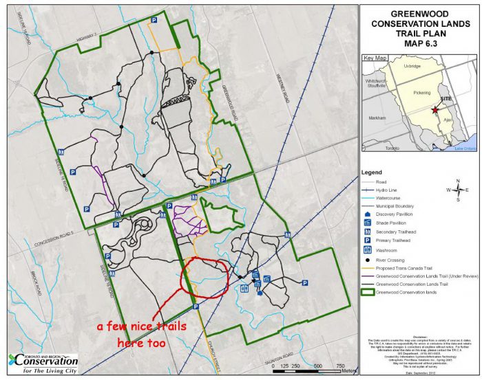
Access – north off  Pickering on Brock Rd. then east  on Taunton Rd. then north again on Church St a gravel road.

Two spots to park on the east side, I like the first the second lot further up has a lot of dog walkers.

Or drive further, go right at the next road, Whitevale and park on the north lot at the bottom of the hill by creek for the other ride area. (underdevelopment)


Greenwood Conservation Area trail system is one of those bike rides made up of a mix of random hiking paths, old farm roads and MTB track cut by the locals. Nothing is organized or connects with much sense, but you can have a bit of fun exploring the lot.

You will find here flat river paths, boardwalks, open fields,  steep valley inclines and an old gravel pit.

There are a few hidden trails that are harder to manage but most are old walking paths and roads.

The best riding is on the south side of the park (red circle on the map) and then north of the gravel pit and beyond. Across Whitevale Rd. at the other end which is under development has a few nice runs.

The two do not connect well and you will have to ride the gravel road north to get to the other half of the trails.

First, on the south side, it starts off easy on hiking paths then you will find singletrack on the SW side that gets more challenging. Some of the older trails that heads down to the river valley has been washed out and a bridge or two are missing.

So currently I would stay on the top for the best riding. You may stumble onto structures that locals have built as you get close to the train tracks. Caution here, as some are poorly built. Avoid! (By now they may have been removed by the park staff.)

The north ride goes from the gravel pit (watch the dog walkers and poo) north past Whitevale Rd. to a large area with a few nice surprises. (like cross the creek without a bridge lol)

At first there are long straight old roads that take you in. One such path curves west up the hill to an open field, and beyond to a ridge that has good riding. I found a few twisty MTB trails on…


Read more of this review in my MTB guidebook with topo maps and riding tips, available as an eBook or paperback.

mtb trail guide

Greenwood bike trails

Reviews
3.4
Total Score 1 REVIEW
Fun Factor: Scenic: Trail Design: Technical: Workout:
Leave a review
Fun Factor: Scenic: Trail Design: Technical: Workout: