Cataraqui – Rail Trail

Strathcona to Smith Falls
Posted on August 24, 2020 / 12502
Cataraqui – Rail Trail
Listing Types : Rail Trail
Location : Eastern Ontario
Note : EPIC Ride
Total Trail Km : 104
Double track % : 90
Road % : 10
Rate Skill Levels : Easy, Intermediate
Terrain : sandy spots, smooth soil, crushed gravel, can be muddy, bridges, flat sections, drains well, open field
Faclities : parking, food close by, lodging, trailhead map, good signage, trails maintained
Trail Fee : Free

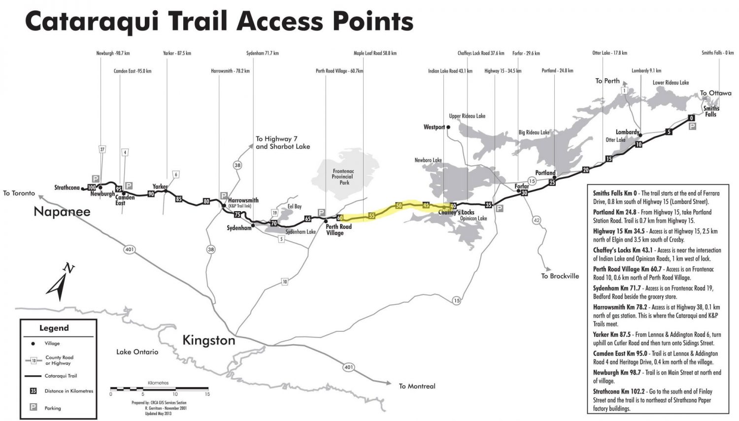
Length – 104  km (one way)

90%  rail trail path double track
10%  road crossings, detours

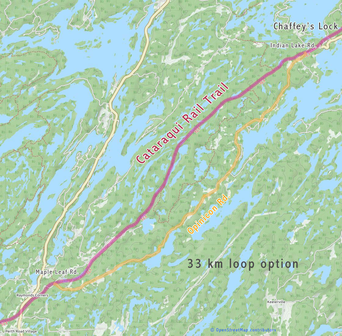
Elevation – gradual elevation changes as expected (optional Opinicon Road loopback, big hills)

Terrain –  crushed stone, gravel,  tall grasses, puddles suitable for hybrid or mountain bike

Skill – easy to intermediate, some terrain is rough

Traffic – bicycles, hikers, horses, cross-country skiers, snowmobiles

Facilities – parking on street, a few out houses, small towns with services

Highlights – iron bridge, chaffey locks, rock cuts, lake views, marshes,

Trail Fee – free

Maps – maps main parking lots, sign posts every few km

Phone – none

Website – Cataraqui Trail,  Facebook page

Similar Trails – Algonquin, Seguin

Local Clubs – Kingston Velo Club

Access – many entry points on route


The Cataraqui rail trail is a popular route for bicycle riders looking to get off busy roads and find solitude. Situated in cottage/farm country north of Kingston, this well maintained trail travels east to west. Starting from Strathcona it runs NE to Smith Falls 104 km away and most of it is part of the Trans Canada Trail system.

For most of the rail trail, the ride is a mix of farm fields and forest. The west end has more towns to stop by. (East Camden, Yarker, Harrowsmith, Sydenham)

In the middle, the landscape changes to more a rocky, hilly variety as the Canadian Shield just dips down a bit from Perth Road onto Caffery’s Lock area.  Next, you are back into flat farm country and fewer towns to pass by (Portland) to finish in Smith Falls — the largest centre.

We rode the section considered the most scenic from Chaffey’s Lock to about Perth Road (16 km). Then we cycled back on the Opinicon Road to our van for another 18 km. At 33 km, the round trip was a wonderful loop I would recommend for any fit cyclist.

Starting a little west of Chaffey’s Lock on Opinicon Rd. we parked up the hill on Indian Lake Rd. where the rail trail runs. As most of the photos show, the trail runs west through…


Read the rest of this review in my trail guidebook, with better maps, parking suggestions & train history when you buy the eBook or paperback.

Vol 2 Bike Trail Book Ad

Cataraqui Rail Trail Access Points Map

Cataraqui Rail Trail Access Points Map


Open Street Maps

Cataraqui bike loop map

Cataraqui bike loop map

Reviews
3.8
Total Score 4 REVIEWS
Fun Factor: Scenic: Trail Design: Technical: Workout:
Leave a review
Fun Factor: Scenic: Trail Design: Technical: Workout: