Cornwall Waterfront – Park Trail

Cornwall to Upper Canada
Posted on September 14, 2018 / 9254
Cornwall Waterfront – Park Trail
Listing Types : Park Trail
Location : Eastern Ontario
Note : EPIC Ride
Total Trail Km : 32
Park Path % : 75
Road % : 25
Rate Skill Levels : Easy
Terrain : paved, flat sections, gentle hills, open field
Faclities : parking, food close by, toilet, outhouse, drinking water, lodging, trails maintained
Trail Fee : Free

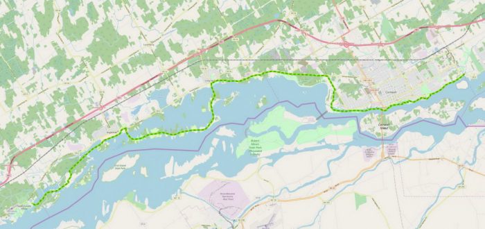
Length – 22 + 10  km (+ 7 – 10 km optional road connection) – one way

75 % park path
5 % crossings, detours
20 % road travel

Elevation – mainly flat, a few gradual inclines

Terrain – dual lane paved, narrow gravel trail on west end

Skill – easy, intermeidate

Maps – little signage, no board maps, follow the painted line waterfront trail

Facilities – parking lot, toilets, amenities, camping, beaches

Highlights – old canal, bird sanctuary, bridges, power dam, Upper Canada Village

Trail Fee – free

Phone – none

Website – St. Lawrence Parkway,  Go Biking, City of Cornwall

Similar Trails –  Rideau Canal, Welland Canal, 1000 Islands

Local Clubs – Cornwall Cycling Club

Access – plenty of parking at Cornwall waterfront, Long Sault, Ingleside, Upper Canada Village


One of the better park rides in Ontario can be found along the St. Lawrence River out by Cornwall. This 22 + km Waterfront Trail has all the desired qualities to make it a great ride being long, never boring, scenic and well-maintained.

Unlike the 1000 Islands bike trail further up the river, this one actually does follow the waterfront closely for most of the journey. The path takes you by marinas, old shipping canals, dams, the fast flowing St. Lawrence, and along the city’s waterfront parkland.

An old riding mate showed me the trail this summer and I thoroughly enjoyed it.

Mainly flat, you will encounter a few long gradual climbs and on the west end, some more narrow gravel trail, all easily manageable, never crowded.

This path had a few signs and map boards that I noticed. We followed the painted centre line and that got us there.

This long path 22 + 10 + 10 km can be divided up into a few stages. Starting from the east end the route follows Montreal Rd. and hugs the shore from Gray’s Creek on the eastern limit of Cornwall. As it gets to the city centre, it opens up to the waterfront parkland.

Beyond, once you pass under the large bridge the path now takes you along what once was the old canal and locks the freighters took. What is odd, is the view of water on each side of your path at different levels.

The route will turn north and inland for…


Read more of this review in my trail guidebook with better maps and suggested parking, available as an eBook or paperback.

Vol 2 Bike Trail Book Ad

Open Street Map     Waterfront Trail

Cornwall bike trail map

Reviews
4.4
Total Score 1 REVIEW
Fun Factor: Scenic: Trail Design: Technical: Workout:
Leave a review
Fun Factor: Scenic: Trail Design: Technical: Workout: