Midhurst – MTB Trail

north of Barrie, hwy 26
Posted on July 30, 2017 / 8305
Midhurst – MTB Trail
Listing Types : MTB Trail
Location : Central Ontario
Total Trail Km : 15
MTB Track % : 35
Double track % : 20
Hiking trail % : 45
Rate Skill Levels : Easy, Intermediate, Advanced
Terrain : smooth soil, structures, logs jumps, crushed gravel, can be muddy, flat sections, large hills, steep hills, twisty & gnarly, tree roots
Faclities : parking, food close by, toilet, outhouse
Trail Fee : Free

Length –  15 km

35% MTB single track
45% hiking trail
20% double track access roads

Elevation – Southern length of area is level. Slopes quickly down to creek on north side.

Terrain – smooth soil base, large sandy areas, occasional rocks and boulders, lots of log hops and wooden structures.

Skill – easy to advanced

Traffic – MTB and pleasure cyclist, hikers with dogs. (watch for poop)

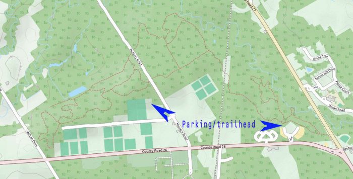
Maps – None, little signage, closed loop system, hard to get lost, locals can point the way out.

Facilities –  parking lot, outhouse, bike repair station at Admin Centre.

Trail Fee – free

Phone – none

Website – Barrie Community Sports Complex

Similar Trails – Dufferin Forest, Glen Major, Northumberland

Local Clubs – none

Access – Two suggested entry points: the very large Barrie Community Sport Complex (where the flag is on the map) or the rear parking lot of the Simcoe County Admin, Centre. 


The Midhurst bike trails just north of Barrie offer a real mix of terrain worth discovering. Here you will find old hiking trails with a few new singletrack MTB loops.

The woods have a variety of structures, large glacial rocks, jumps and log rollovers to keep things interesting.

Many of the trails are hiking loops, but there are occasionally some decent MTB side trails that are a challenge to ride.

The trail system basically has an upper route and a parallel lower trail running by the pond and Willow Creek. Numerous side trails connect down the hill from one to the other. I did find some fast DH runs for a twisty MTB rush, though brief.

When you get to the pond/lake (when does a pond become a lake, I wonder?) you can ride around it. That seems to be the limit of how far you can go north.

Tight & Twisty is a short singletrack, in the middle of these woods, a gauntlet of log jumps/rollovers, the most I ever saw coming at me in 15 minutes of hauling it. Oh, what fun!

Eventually, there are train tracks and sideroad crossings that will slow you down a bit on what is otherwise a fast ride. Find the trail where the train crosses over the creek—it will take you down under the span of an old bridge.

On the east side of the tracks, the main trail opens up and gets very sandy. You’ll have a chance to try a collection of formidable ramps.

You will find boardwalks, skinnies, teeter-totters and jumps of all sizes. These really add some spice to the menu. (Note: There are some other old wooden structures I would not trust.)

At the far end, one of the best singletrack loops


Read more of this review in my MTB guidebook with topo maps and riding tips, plus 54 others. Available as an eBook or paperback.

mtb trail guide

Open Street Map

Midhurst bike trail map

Midhurst bike trail map

Reviews
3.8
Total Score 2 REVIEWS
Fun Factor: Scenic: Trail Design: Technical: Workout:
Leave a review
Fun Factor: Scenic: Trail Design: Technical: Workout: