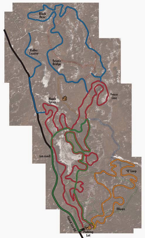
Forest Lea – MTB Trail

1864 Forest Lea Rd, Pembroke
Posted on September 20, 2019 / 2504
Forest Lea – MTB Trail
Listing Types : MTB Trail
Total Trail Km : 30
MTB Track % : 80
Double track % : 20
Rate Skill Levels : Intermediate, Advanced
Terrain : sandy spots, structures, logs jumps, bridges, flat rock, gentle hills, twisty & gnarly, tree roots, rocky patches
Faclities : parking, food close by, trailhead map, trails maintained
Trail Fee : Donations

Length – 30 km

80% MTB single track
20% double track access roads

Elevation – Gradual short climbs; level around the lake and marsh area.

Terrain – A mix of random roots and rocks, with smooth soil in between. Note bridges, berms, flat rock, muddy and sandy patches. Some sections are overgrown by late summer.

Skill – Intermediate to Advanced

Traffic MTB riders, hikers, horseback riders; not a busy location.

Maps – Map board at the trailhead, small old signage on trails. 

Facilities – Parking lot, outhouse.

Highlights – Lake view, bridges, garden gnomes in a wilderness setting.

Trail Fee – Free, but consider the $20 annual membership to support maintenance.

Phone – None (signal weak)

Website – Forest Lea Blog

Similar Trails – South March, Hilton Falls, Puslinch

Local Clubs – Ottawa Mountain Bike Association

Access – West of Pembroke at the end of the Forest Lea Road at 1846 is a large parking lot. Right side of the Nordic ski cabin is the MTB trailhead.

The MTB trails start on the snowshoe loops that Fatbikes can use, but they are short. Riding on Nordic ski tracks in the winter is not cool, and damages it. Continue your ride on the side roads or the snowmobile paths, please.


Just west of Pembroke, 30 km of technical trail awaits you at Forest Lea. All MTB riders keen on a challenging, yet enjoyable rocky, rooty single track need to check this remote location one day.

Tucked away in eastern Ontario, close to the Ottawa River, where the wilds of the north can be felt, sits this little-known set of tracks. 

Mountain bike riders will find little here that is Easy, as much of the trail moves at an Intermediate pace with occasional moments that call on your Advanced skills to be employed.

Aside from the flat access roads and overgrown nordic ski paths, much of the terrain is a mix of random rounded rocks and tree roots on single track. Though at times challenging, none of the gnarly sections were impossible, insane or endless. 

Thankfully the tough stuff was not relentless, and interrupted by sections of clear trail to relax briefly and set up for the next upcoming series of challenges. A full suspension bike with large rims would improve your efforts.

Not an overly hilly place, the terrain undulates with small changes in elevation and a few short climbs are found on the west side.

If this sounds like more work than fun, then it’s likely not your thing. Mountain bike clubs in the Ottawa Valley regularly visit this location. Since it is not a busy place, you will need to be equipped to not get lost.

We rode the Red trail (the most popular) taking in sections of the easier Green trail as well. We enjoyed the twisty loop as it took us over long bridges to the lake for a scenic view. Then we passed through the playful Enchanted Forest section with garden gnomes between the rows of tall pines.

I would like to say…


Read more of this review in my MTB guidebook with topo maps and riding tips, available as an eBook or paperback.

mtb trail guide

Forest Lea trail map

Forest Lea trail map

Reviews
4.2
Total Score 1 REVIEW
Fun Factor: Scenic: Trail Design: Technical: Workout:
Leave a review
Fun Factor: Scenic: Trail Design: Technical: Workout: