Length – 35 km
40% MTB single track
25% hiking trail
35% double track access roads
Elevation – large hills and valleys (by Ont. standards) on the north and south end, more level in the middle
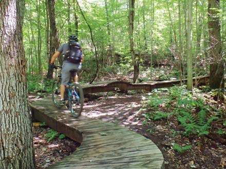
Terrain – smooth soil, a few rocks and roots, sandy on north end, some gravel, drains well after a rain
Skill – all levels, best for intermediate MTB, and intermediate Park style ride
Facilities – parking lot (can get busy), outhouse, no food or water close by
Highlights – lots of variety for all level, fast gnarly hilly track, new ramps built
Maps – at trailhead and a few in the interior, post markers on access roads junctions
Trail Pass – free
Phone – 905-895-1281
Website – Lake Simcoe Region
Similar Trails – Glen Major, Dagmar, Albion Hills,
Local Clubs – DMBA (Durham Regional Mountain Biking Association) does a great job maintaining and developing trails, plus scheduling rides.
Access – Driving up Brock Rd. from the 401, go east on hwy 21 to Concession 7 is the paved route.
Park on the side of the access road in. At the large map and gate, most riders head south or east to start a ride.
As MTB riders you may want to do the alternate rough gravel route which is coming up Con. 7 from hwy 5. This passes the Glen Major and Dagmar trailheads too.