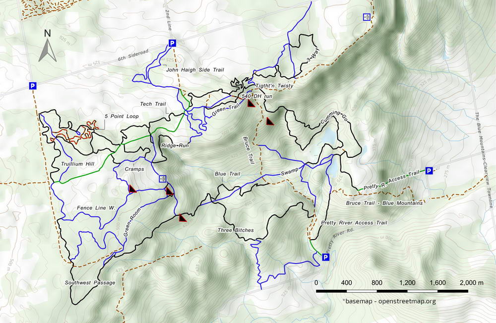
Three Stage – MTB Trail

Side Rd 6 & 2 Line, Collingwood
Posted on July 10, 2020 / 13668
Three Stage – MTB Trail
Listing Types : MTB Trail
Location : Central Ontario
Note : EPIC Ride
Total Trail Km : 40
MTB Track % : 50
Double track % : 20
Hiking trail % : 30
Rate Skill Levels : Intermediate, Advanced
Terrain : smooth soil, logs jumps, water crossing, can be muddy, large hills, steep hills, open field, twisty & gnarly, tree roots, rocky patches
Faclities : parking
Trail Fee : Free

Length – 40+ km

50% MTB singletrack
30% hiking trail
20% doubletrack access roads

Elevation – One of the highest points on the escarpment, this bluff drops down in three stages. The top area slopes to the edge of the bluffs, then drops steeply to a terraced level area, then descends to the base.

Terrain – Smooth soil base, random limestone outcrops, log hops, well treed, mud patch and slippery when wet.

Skill – Intermediate – Advanced

Traffic – Light MTB usage, hikers; winter sees Nordic skiing and snowmobile trail use.

Maps – Little signage, no map; one could get spun around and lost; use a GPS phone app

Facilities – Small parking lots; pack what you need

Highlights – Tons of good-quality trail, fast flowy and gnarly rock, DH runs, lookouts, tasty apples

Trail Fee – Free

Phone – None

WebsitePretty River Provincial Park

Similar Trails – Agreement Forest, Kolapore UplandsHilton Falls

Local Clubs – Team Van Go

Access – From Collingwood, follow Grey County Rd. 19 southwest towards Osler Bluffs ski hill; take 19 to the top of the hill. Moments later, turn south on 2nd Line, a dirt road. Drive south ’til you meet Side Road 6 and park where you can. Two trails going south get you in.

Or park west at the next intersection (at 3rd Line) and head south from there.

In 2023 Ontario Parks closed some trails to hiking/mountain biking. Bummer.

The park is under review. Appretanly there were rouge trails and unsafe structures popping up. Possible wildlife damage and hazards were flagged. Please say off these mark trails.


Up on the bluffs of the Niagara Escarpment, minutes away from Collingwood, resides Three Stage. This trail network within Pretty River Valley Provincial Park calls riders in search of that elusive MTB zen.

They call it Three Stage for the states of fulfilment achieved the longer you ride there. Somewhat plausible? It actually refers to the three levels of the hill.

Most of the trails are on the top of the bluffs; halfway down is the second stage, where the land levels out as a terrace, and then finally there’s the bottom level, where a country road passes.

More track is found on this plateau with fast downhill routes between stages. There is little to ride on the bottom.

Since this is one of the highest points on the escarpment, you can imagine there is a lot of climbing, especially if you take the downhill routes. For some, these seldom found DH runs are worth the buzz.

Most are satisfied staying at the top exploring this large forest. The 40+ km of trails here are wild, with little maintenance: the park is not operational, so you’ll find no infrastructure or services. You are free to roam and get lost.

For decades, this has been a quiet spot that only experienced mountain bikers should try. It’s rustic, rugged, hilly and tons of fun.

Some routes are hiking paths, while others were cut with MTB riding in mind. With no map and few trail blazes or landmarks to help you get around, it becomes an adventure…


Read more of this review in my MTB guidebook with better topo maps and riding tips, plus 54 others. Available as an eBook or paperback.

mtb trail guide

Open Street Map   sample of topo maps found in my MTB book

Three Stage MTB trail map

Three Stage MTB trail map

Reviews
4.9
Total Score 2 REVIEWS
Fun Factor: Scenic: Trail Design: Technical: Workout:
Leave a review
Fun Factor: Scenic: Trail Design: Technical: Workout: