Short Hills – MTB Trail

Pelham Rd. & Gilligan Rd., St. Catharines
Posted on July 26, 2017 / 2041
Short Hills – MTB Trail
Listing Types : MTB Trail
Location : Central Ontario
Total Trail Km : 48 km
MTB Track % : 30
Double track % : 30
Hiking trail % : 40
Rate Skill Levels : Easy, Intermediate
Terrain : sandy spots, smooth soil, paved, crushed gravel, flat sections, large hills, open field, tree roots
Faclities : parking, food close by, toilet, outhouse, lodging, trailhead map
Trail Fee : Free

Length − 48 km

30% MTB singletrack

40% hiking trail

30% doubletrack access roads

Elevation − Hills and yes, they are short! And some are mean. Level riding in the valley or on top of the escarpment

Terrain − Loam, sandy, muddy spots, stones, gravel, pavement, bridges, water crossings, some tasty hidden singletrack

Skill − Easy to Moderate

Traffic – MTB riders, lots of hikers, tourists, horses

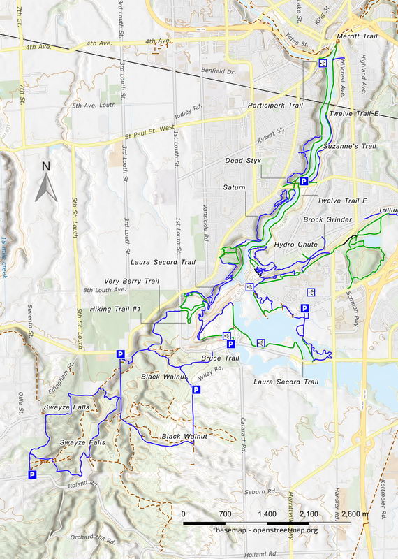
Maps − Signs for hiking trails, the two park loops, you ride on not much else. Bring a map

Facilities − Parking lot, outhouse, no services at the provincial park

Highlights − Scenic, lookouts, waterfalls, bridges, dam, old mill, Brock University.

Trail Fee − Free

Phone − 905 774 6642

Website − Ontario Parks

Similar TrailsDon Valley, Guelph Lake, Fanshawe

Local Clubs − Short Hills Cycling Club, FB page

Access – There are many possible parking locations in the area. The favoured one is at Short Hills Parking Lot A, at Pelham Rd. (Regional Rd.69) and Gilligan Rd.

Or you can park at the mill, at 2749 Decew Rd., or on the university grounds.


Down south of St. Catharines, the Short Hills trail network is an easy-flowing cross-country MTB tour. With about 48 km of off-road riding, this long route is a collection of different paths and constantly changing scenery.

When riders refer to Short Hills, they usually mean not only the provincial park by the same name but also the trails heading north around Brock University and down the Twelve Mile Creek.

It is an enjoyable, scenic ride through forests; across fields and bridges; by waterfalls and dams; and through a creek valley into suburbia. It has views of the city and tourist spots to visit − the historic Morningstar Mill, Decew and Faucet Falls and the university grounds.

It’s also a jumble of trails and paths that connect with little signage to keep you on track. Parts of it are the Bruce Trail and the Laura Secord Legacy Trail; other sections are non-descript short MTB lines you can have fun on. Few are technical or require a full-suspension MTB.

Starting in the Short Hills park, there are only two large loops: the 5 km Black Walnut and the 6 km Swayze Falls. Both are a mashup of dirt and gravel hiking trails and old farm roads crossing fields and weaving through woodlots. Each has a 60 m climb on them; the Walnut route seems harder.

Leaving the park and heading NE, you have two options…


Read more of this review in my MTB guidebook with better topo maps and riding tips, plus 54 others. Available as an eBook or paperback.

mtb trail guide

Example of the trail map from the MTB guide.

Short Hills trail map

Short Hills trail map

Reviews
3.6
Total Score 1 REVIEW
Fun Factor: Scenic: Trail Design: Technical: Workout:
Leave a review
Fun Factor: Scenic: Trail Design: Technical: Workout: