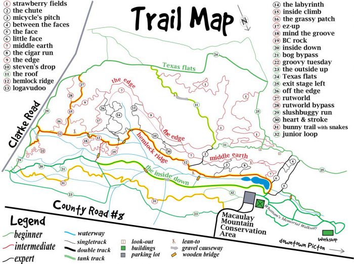
Macaulay Mt. – MTB Trail

224 County Rd. hwy 8, Picton
Posted on March 5, 2018 / 9533
Macaulay Mt. – MTB Trail
Listing Types : MTB Trail
Location : Eastern Ontario
Total Trail Km : 25
MTB Track % : 50
Hiking trail % : 50
Rate Skill Levels : Intermediate, Advanced
Terrain : logs jumps, can be muddy, bridges
Faclities : parking, food close by, toilet, outhouse, trailhead map, trails maintained
Trail Fee : Free

Length – 25 km

50% MTB single track
50% hiking trail

Terrain – loops slope up the hill (it’s not a mountain lol) plenty of off-camber trail, levels off at the top

Surface – smooth soil, can be muddy, some gravel sections, limestone rocks, a few roots and small bridges

Skill –  not much here for a beginner, best for seasoned riders

Trail Maps – at the trailhead, none on the trail, no signposts?

Facilities – large parking lot, picnic shelter

Highlights – A variety of challenging trail, lookout sort of, pond

Trail Fee – Free

Phone – 613 968 3434

Website – Quinte Conservation

Similar Trails – Ravenshoe, Waterdown,  Copeland

Local Clubs – Bloomfield Bicycle Club on FB,  MTB Riders of Macaulay MT. FB

Access – Just outside of Picton south on Union St. 224 Country Rd. hwy 8 park entrance on the west side.

Trailhead from the parking lot, take either side of pond, numerous entry points on the south side of the park road coming in.


Macaulay Mt. Conservation Area is well, not a real mountain but local MTB riders like the hill anyway.

Just south of the town of Picton in Prince Edward County, these forest bike trails have some challenging elements as you ride the many twisty and off-camber hillside loops.

The local Bloomfield club has been involved for many years in building connecting trails that switchback between straighter hiking paths across the hill.

One can climb up to the ridge rather effortlessly on them where it flattens out for the other half of the trails. You will find the easier riding at the base of the hill and on the top plateau.

This trail system has a few boardwalks, no structures to play on and random rock outcrops of limestone but not tons of it.

There is a map at the trailhead but it serves little use as there are no reference posts on the trails and the trails split often.

This can be fun to explore this way and that. You might get a little lost but listen for the road traffic and just by heading to the bottom of the hill, you will get back to the parking lot by the pond.

A lot of the brush has blocked the lookouts up top. Pick your descents as some are scary gravel bombers.

Avoid riding when it’s wet as a lot of off-camber trail is not benched and you will go down my friend.

It’s a humid, dense forest with hemlock and cedars so expect bugs till the fall.

One of the best MTB rides in the area for those who like exploring lots of twisty track with rocky elements for kicks.


2022 – I recently heard that this location has been neglected and maybe not so MTB awesome anymore. Riders, leave a review to update the state of Macaulay for everyone, svp. 


This one’s not in my MTB trail guide, but 55 others are, with better topo maps and riding tips. Available as an eBook or paperback.

mtb trail guide

Macualay bike trail map

Macualay bike trail map


Reviews
3.6
Total Score 1 REVIEW
Fun Factor: Scenic: Trail Design: Technical: Workout:
Leave a review
Fun Factor: Scenic: Trail Design: Technical: Workout: