Victoria – Rail Trail

Lindsay to Haliburton
Posted on October 17, 2020 / 12329
Victoria – Rail Trail
Listing Types : Rail Trail
Note : EPIC Ride
Total Trail Km : 85
Double track % : 95
Road % : 5
Rate Skill Levels : Easy
Terrain : sandy spots, crushed gravel, drains well, open field
Faclities : parking, toilet, outhouse, trailhead map, good signage, trails maintained
Trail Fee : Free

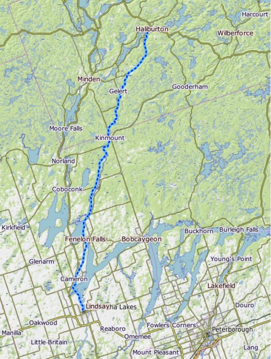
Length –  85 km (one way)

90% rail trail path
10% road crossings, detours

Elevation – Flat as she goes with a few noticeable inclines 

Terrain – crushed stone, gravel, asphalt, very sandy and rocky north of Kinmount.

Skill – Easy, north part difficult

Maps – A few map boards, well marked.

Traffic – Bicycles, hikers, horses, ATVs, dirt bikes, snowmobiles, Nordic skiers

Facilities – Limited parking, towns of Lindsay, Fenelon Falls, Kinmount and Haliburton have food, lodging & toilets, bike share station by locks

Highlights – Wilderness, Waterfront cottages,  Fenelon Falls & locks, Highlands Cinemas in Kimount, old train stations and old locomotive in Haliburton

Trail Fee – Free

Phone – 705 324 9411

Website – Kawartha Lakes

Similar Trails – Victoria South, Uxbridge Lindsay,  N. Simcoe + Tiny

Local Clubs – Peterborough Cycling Club

Access –

  • Lindsay: Trail starts north of Pottinger St. on Victoria Ave. N with only street parking. 
  • Fenlon Falls: If you are heading south park at the old train station or  park near the locks around Garnet Graham Beach Park 
  • Kinmount: Austin Sawmill Heritage Park
  • Haliburton: Gelert Rd.

History – (I no longer include train history in my free reviews. Only to be found in my published books.)


The Victoria Rail trail is a popular 85 km route running north through Ontario farm fields into the forests of cottage country. A long and winding path that keeps cyclists engaged with the ever-changing geography that passes by from Lindsay to Haliburton.

Over the years I have ridden separate sections and it being so long and different, I think it best to divide the Victoria RT into three parts. 

From the south end in Lindsay, it starts as a  paved path but soon enough, as you leave town it becomes that familiar crushed fine gravel rail bed riders are used to. There are a few odd larger stones to avoid but little else to be concerned about.  

Soon you pass through a rock cut to cross the open wetlands of Sturgeon Lake. Stop for a moment at the bridge to take in how large this marsh is.

After there is a little bit of a climb to some nice scenic vistas over farms and fields. This part is an open trail with no shady woodlots to pass through. The going is pleasant right to the old train station in Fenelon Falls 20 km away.

To get to the next section of the trail a short road riding is required as the train swing bridge is only in use in the winter for snowmobiles. No matter, taking Lindsay St. (in Fenelon Falls; confused?) to cross the only bridge in town, this leads you to the locks and waterfalls, a worthy sightseeing stop.

If you start your ride in this summer tourist town, head north of the locks along the waterfront. Take note of returning after your ride to the pizza, craft beer and ice cream storefronts by the locks, a perfect triad. Yum!

This trail takes you along the waterfront of Cameron Lake by fancy cottages and docks. Then up the Burnt River through forests and fields to Kinmount for 30 km

Along the way, there are opportunities to…


Read the rest of this review and 59 others in my NEW book, Volume 2 of Best Bicycle Park & Rail Trails in Ontario.

Vol 2 Bike Trail Book Ad

Victoria Rail Trail map

Victoria Rail Trail map

Reviews
4.1
Total Score 2 REVIEWS
Fun Factor: Scenic: Trail Design: Technical: Workout:
Leave a review
Fun Factor: Scenic: Trail Design: Technical: Workout: