Upper Humber – Park Trail

Humber River, Toronto
Posted on June 22, 2018 / 7119
Upper Humber – Park Trail
Listing Types : Park Trail
Total Trail Km : 20
Park Path % : 95
Road % : 5
Rate Skill Levels : Easy
Terrain : smooth soil, paved, gentle hills, open field
Faclities : parking, food close by, toilet, outhouse, drinking water, trailhead map, good signage, trails maintained
Trail Fee : Free

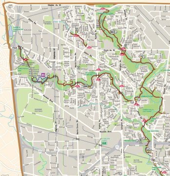
Length –  20 km (one way)

90% park path
10% road crossing, detours

Elevation – level, follows the river valley gradual slope

Terrain – wide path, paved asphalt, dirt path at the end

Skill – easy

Maps – good signs, a few maps

Facilities – parking at many parks, benches, kid play sets, only 3 restrooms at Rowntree Mills Park, Ester Lorrie Park and the Arboretum.

Highlights – bridges, natural park setting, arboretum, dam

Trail Fee – free

Phone – 311

Website – City of Toronto

Similar Trails – Humber River south section, lower Don Valley, Highland Creek

Local Clubs – Toronto Bicycle Network, Toronto Bicycle Club

Access – Best place to start is at the south end parking lot at the end of Dee Ave.

Also other lots at local park are at – Pine Point, West Humber Parkland,  Esther Lorrie Park, Humber College, Blue Haven Park, Rowntree Mills Park


The upper forks of the Humber River offer 20 km of some of the best Park trails to ride in the city. Here, in the northwest corner of Toronto, runs an easy, long, and enjoyable bicycle route that branches off in two directions.

Starting just below Hwy 401 the path winds north for 4 km, where it forks west for another 10 km; or, take the right way north for 6 km more.

The ride is enjoyable and varied with no outstanding features, just your typical open, and somewhat natural parkland setting, complete with mowed greens and park benches.

Bridges take you across the river a few times, and numerous spur trails lead into local neighbourhoods. I doubt riders will get lost if they follow the river and avoid any side paths. Thankfully, the signage seemed adequate.

The trail goes under most road crossings, with only Albion Rd. requiring you to cycle up to the roadway and cross at the lights.

Taking the west branch of the Humber River Trail will lead you to the dam at the Claireville Reservoir. On the way, there is the Humber College Arboretum, which may be of interest to some. (I found it a nice break to walk about the gardens.)

The other north branch meanders…


Read more of this review in my trail guidebook, plus 64 others. Featuring better maps, more parking locations and elevation graphs. Available as an eBook or paperback.

Vol 2 Bike Trail Book Ad

Full map PDF - 4MB

Upper Humber River bike trail map

Reviews
4.2
Total Score 1 REVIEW
Fun Factor: Scenic: Trail Design: Technical: Workout:
Leave a review
Fun Factor: Scenic: Trail Design: Technical: Workout: