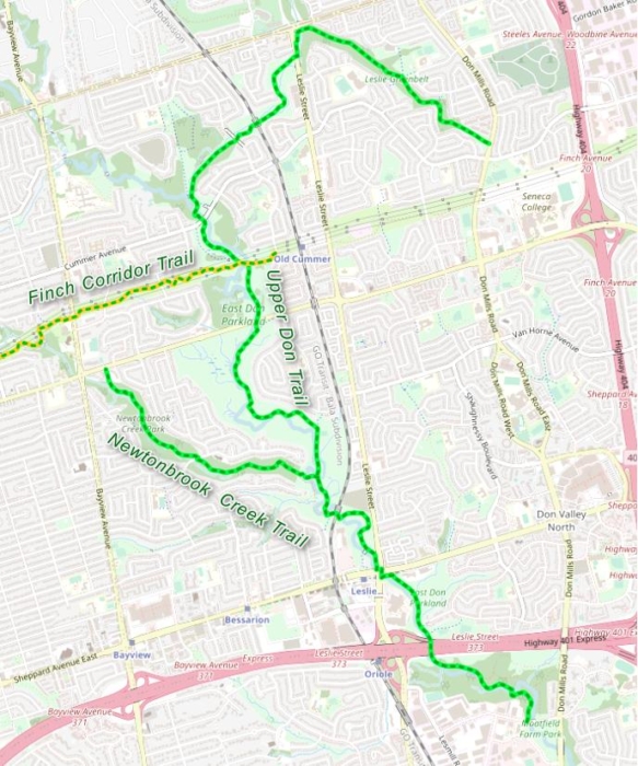
On the north end of Toronto resides a shady bicycle path through ravines along the Upper East Don River. This 9 km Park trail makes for a nice relaxing outing for many who live close by in need of a getaway.Â
This meandering path follows the east arm of the Don River from just below hwy 401 on to Steeles Ave. and then curves back down to Don Mills Rd.
We started our trek on the south end, entering from Duncan Mills Rd. to ride the short Betty Sutherland Trail. The route under the sixteen lanes of the highway was surreal and this took us to Sheppard Ave. onto another odd bridge. Actually, this trail has a multitude of bridges to cross, be it over water or under roads and train tracks.
At Sheppard Ave. you have to use the lights to cross this large intersection. On the opposite corner, the trail continues down into the woods again now official as the Upper Don trail.
What makes this path so pleasant is the sense of being out of the city in nature. It has very little manicured parkland and none of the usual open playgrounds and picnic areas. You will find this to be a nice change from the familiar city sights.
It also offers numerous side trails to check out to make it a longer ride. The first fork is the 2 km Newtonbrook path to the NW, it’s been kept as a natural surface and will be a bit of a rougher ride.
Another is an open path following the hydro field towers. The Finch Corridor trail goes up a large hill due west for 13 km and can take you far across town. But frankly, the lack of good scenery as you ride underneath the power lines is not the kind of outing I recommend on this site.
Eventually, at the top, the path meets Leslie St. You will need to cross at the lights to take the Duncan Creek ravine trail SE 2 km to Don Mills Rd. (Though I am mentioning this a little early, as the city just put in a new bridge which is due to open in spring 2021)
Once complete, it can be an option to loop you back down to your start point by road riding south on Don Mills Rd. for 5 km.Â
On our ride, I did not see any deer this time around, just many walkers and cyclists using the trail on a fine summer day.
I found the pavement is in good shape though the signage is a little disjointed. You may have to refer to a map. I know the city is replacing it’s cycling signs and I hope they paint a line down the centre too.
Make your way over one day to this neck of the woods to enjoy one of the many Toronto natural ravine rides that exist.
* There will soon be a lower East Don trail to ride. Construction is almost complete!