Two Lakes – Rail Trail

Belleville to Madoc
Posted on April 18, 2019 / 6060
Two Lakes – Rail Trail
Listing Types : Rail Trail
Location : Eastern Ontario
Total Trail Km : 38
Double track % : 95
Road % : 5
Rate Skill Levels : Intermediate
Terrain : crushed gravel, bridges, flat sections, open field, rocky patches
Faclities : parking, food close by, good signage, trails maintained
Trail Fee : Free

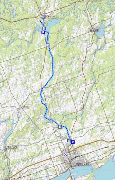
Length – 38 km (one way)
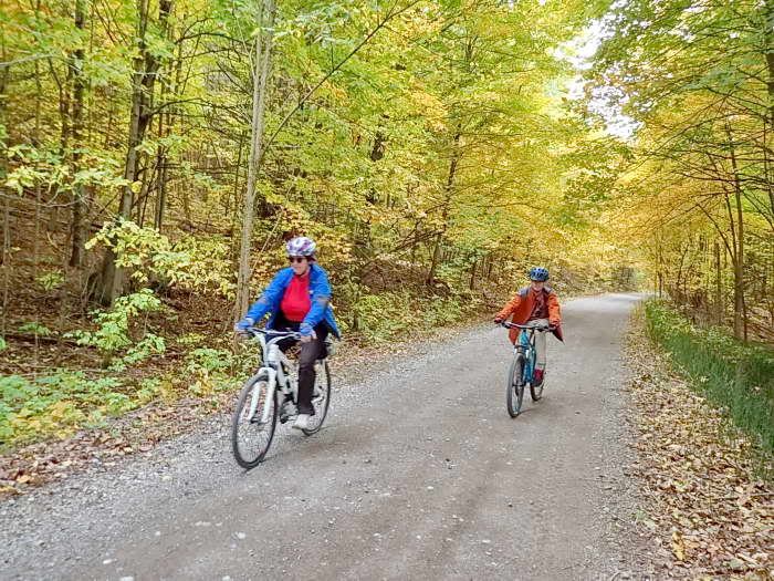
95% rail trail
5% roads, detours

Elevation – A gradual slope northward.

Terrain – The trail is made of crushed stone and gravel, with some large stones and potholes.

Skill – Intermediate.

Traffic – Bicyclists, hikers, horseback riders, ATVs, and dirt bikes, as well as snowmobiles in winter.

Maps – Plenty of signage, much of it for ATV vehicles.

Facilities – Parking lots, food, and lodging can be found in Belleville and Madoc.

Highlights – Bridges, shaded forest, and natural wetlands, as well as Moria Lake, and the town of Madoc.

Trail Fee – Free.

Phone – 613-478-1444

Website – The Trail

Similar Trails – Cataraqui,  Seguin

Local Clubs – Kingston Velo Club, Bloomfield Bicycle Club

Access – From side roads or two parking lots: one at the south trailhead where River Rd. and Cannifton Rd. N. meet, as well as on the other end of Moira Lake, at Hwy 62 and Watson Lane.


The Trail of Two Lakes runs for 38 km north from Belleville and up to Madoc along an old rail bed.

This Rail trail is your typical, multi-use repurposed rail line and is more known (and used) by ATVs and snowmobiles than cyclists. As such, the surface terrain is coarse with the odd pothole and is better suited for Intermediate riders.

Since the path is unlike the fine, crushed stone of other Rail trails, a good hybrid bike with shocks or, better, a mountain bike or Fatbike is the ticket.

Bicyclists and hikers are welcome, just know that motorists are likely to pass on your ride. (We encountered perhaps eight ATVs on our trek, but they slowed down and were friendly folk.)

The railbed continues along, with gentle curves and not too many straight sections that felt endless.

Riders will come across many marshlands, giving open views and a break from the forest canopy.

One would think the bugs could be a problem in the spring, but I did not find this the case during my ride in the fall.

Along the way, crossing country roads reveals small communities with cottages and farmers’ fields.

For the most part, this is a quiet, nature-filled bike ride. You may see turtles crossing the road, or songbirds in the marshes.

Just before Mudcat Rd. is the largest bridge on the trail; an old iron bridge spanning the Moira River.

I did note a long climb (harder for a train than you!) after Smith Rd. Listen for Rawdon Creek running alongside.

Right after Tuffsvile Rd. the rail line splits, another Rail trail branches…


Read the rest of this review in my trail guidebook along with 64 others. Features train history with better maps, elevation graphs and parking locations when you buy the eBook or paperback.

Vol 2 Bike Trail Book Ad

Two Lakes rail trail map

Two Lakes rail trail map

Reviews
3.6
Total Score 1 REVIEW
Fun Factor: Scenic: Trail Design: Technical: Workout:
Leave a review
Fun Factor: Scenic: Trail Design: Technical: Workout: