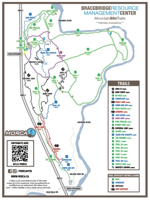
Length – 17 km
50% single-track
50% double-track path
Elevation – Stone ridgeline runs parallel to the highway with the area sloping down to the river.
Terrain – Smooth soil base, random rock outcrops, boulders, boardwalks, and a gravel mix on access roads.
Skill – Best for Intermediate / Advanced MTB riders; Intermediate Park type ride on the access roads.
Traffic – Two way trails, light use by local hikers and cyclists. Active Nordic skiing area in winter. Fatbikes only on the snowshoe trails in the winter. No grooming is currently done.
Maps – Map at the trailhead, as well as new signpost maps.
Facilities – 3 Parking lots, with outhouses, shelter and benches on the trail.
Highlights – New MTB track on ridgeline, additional trail being developed. Scenic river and rapids.
Trail Fee – Donation post – pay what you can
Phone – None
Website – MORCA, BRMC on Facebook
Similar Trails – Buckwallow, Porcupine Ridge, Naughton
Local Clubs – Muskoka Off Road Cycling Assoc. MORCA on Facebook
Access – Two parking areas now exist. A new south end parking lot was added, with the entrance on the north side, on Holiday Park Dr. just 100 meters east of Hwy 11 interchange. This new entrance is best suited for seasoned MTB riders.
The main parking area is further up 2.5 km north, right off Hwy 117. There is only one Hwy. sign posted mere seconds from the turnoff (!), so start hitting the brakes as soon as you see it—the turnoff comes up suddenly, and if the highway is busy I find this a tad dangerous.
Do not miss that turn, or you are in for one long loop around with a rather significant U-turn up, around and back down to the interchange.
If you need to go back home by the south route later, this requires you to drive up the highway to the next crossover a few kilometres up the road.